
Tower light house in India is important for navigation

THE VEDIEO AND PHOTO FROM LIGHT HOUSE IN VALIYA AZIYIKAL BEACH KERALA
Posing to the Camera inside a light house in Valiya Azikkalbeach kollam
 |
 |
 |
 |  |  |
E NAVIGATION GIS MAP AND ENC CHARTS

Topography is on Natural Features, Cultural features, landmark, ports
Hydrography is the Tides and current. Depth, Nature of Sea Beds , Rocks, Wreck and obstruction, offshore Installation , Tracks and Routes , Area and Limits .
Navigation Aids and Services is on Lights , Buoys and Beacon, Fog Signals , Radar, Radio and Satellite Navigation System
1 Route Monitoring
2 Collision Avoidance
3. Provide Manual and / or Automatic Navigation control functions
The INS Navigation semsors
1 Electronic Position Fixing System
2 Heading Control System
3 Depth Sensor
4 Speed and distance Measurement
5 Collision Avoidance
6 Route planning and monitoring
7 Track control system
The Navigator uses the integrated Navigation System for the safe passage by the visual and data in the chart .The Intergrated Navigation system is used to plan a methodology for the safe passage
1. To know the position of the ship and surrounding in the route
2. To scan the location by maps in the integrated navigation system when the visibility in less in night to track the route and surrounding places
3 E Navigation System in the integrated Navigation system give a glance of enter data in the route and can be scanned from left to right and center to left and center to right
4. The time taken in a route depend on the traffic in the route , surrounding area if the ship like bad weather , obstacle in the route mapped even if the distance is less or speed .
E- Navigation is to improve the electronic communication exchange to Enhance Berth to Berth Navigation, to promote safety , security and environment, and to increase efficiency in Maritime transports
The Navigation data base consist of Route symbols and AbbreviationsAbbreviations in 1:50000k scale intergrated navigation system
Preprocessing , digitizing , data charting , symbols and abbreviation the charts in GPS location giving the location. , distance , height , depth. ,route , geographical elevation by contours. Tidal path, inland navigation, cabals, forest and urban area from RNC to satellite ENC
The symbols and Abbreviations
Triangular point, Observation point, fixed point, Bench Mark, Boundary Mark, distance along waterways visible and not visible,
Symbols with text in center and bottom, point symbols , Accurate and approximate symbols , International nautical miles is 1832 Miles , Special characters
Coastline surveyed and not surveyed , flat coast , sandy shore, stony shore , Sand hills , Dunes, international boundary on land and sea. , sea walls, territorial sea base line, beaches
Contour lines with spot and approximate height or depth , Contour form lines , drying contours depth
Trees height , woods, decidious tree, cornifirous tree , palm, nipo palm, casuarinas, filao, Rucalypt, Mangrove,
Cliffs Hillocks, Marsh, swamos, Reedbeds ,park
Urban, settlements , inland villages. Building, important building, build up areas , street names, road names, ruined lands. Motorways. Roads, railway and stations, cutting, embankment , tunnels , airports, heliports, bridge vertical and horizontal clearance , opening bridges. Swing bridges, lifting bridges, bascule bridges, pontoon bridges, DRW bridge, transponder bridge,
City , public building , telegraph and telephone offices , causeway, inland bridges , stadium, landmarks, factory , water tank, light house, church, church tower, church spur, church oupola, chapels, cross, calvary. Temple, pagoda. Shrine. House, Buddhist temple, mosque. martabul, cemetary , town, water tank, chimney. Monuments , windmill, wind turbine. Wind motors. Wind farms. radar, television. Towers, radar towers, scanner, dish aerial, tanker site, fortified structure, forts, castle, mines, caravan sites , campus sites ,
Overhead cables. Transponders, Aerial cables , power cables. Telephone, telegram, pipe, pipeline on land and sea
Eddles, tidal stream data, narrow channels, depth, drying water course , tide way, dredged channel, shallow water area.
Rivers , interninent rivers. Rapids, Waterfall, delta, Lakes and salt lakes,
Glaciers and lava
Marine fish, fish trap area , shell fish beds ,
Oilfield, wind farm, wind turbine, oil derick, oil and gas , submerged production well, suspended well
Rocks, rock height. Wreck. Instruction piles, under water turbine, danger lines , Area of stone and gravels, cirel reeds, islands, shell weeds , spring in sea ,
Radar, radar area. Radio reporting lines ,
Ferry, cable ferry
Berth, Anchorages in no and names, tanker Anchorage. Explosive anchorage. Quarantine anchorage. Reserved Anchorage. Sea plane, sea plane anchorage ,
Fishing prohibited , environment srnsive area. Bord sanctuary area. Sea park, marine reserve , limits of fishing in restricted waters , obstruction and limits
Mine & explosives. Dumping ground, degaussing range. Speed limits, firing & military practices mine laying, submarine mine field ,custom limit, harbour limits, ice , sea ice, floating barriers, dredging, diving prohibited,
Lights , light house, lighter horw , lighted beacon tour. Navigation lights, ports, signal station, refugee office, boarding, AIS and AIG , fig lights, buoys
RNC - Raster Nautical charts

ENC - Vectar Electronic Nautical Charts


Route map by SUEZ CANAL

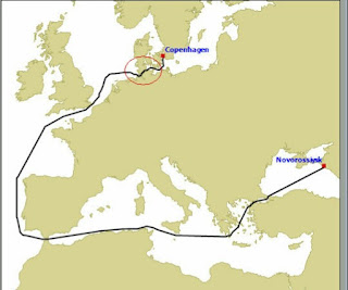
Route map from RUSSIA to EUROPE
MEGA LIGHT HOUSE IN PORTS CONNECTING PORT CITY TO METRO CITY TO SAFE GUARD SHIPS IN INDIAN TERRITORY


 ----
----


Georgie s Cherian

Electronic Chart Display Information System (ECDIS)
A Majority of Cargo Ships, Tanker , Passenger Ship and Mega Yachts used ECDIS in vessels contain Appropriate electronic charts for the vessels intended voyage
ECDIS display RNC charts in Raster and EBC charts in vectar graphics pictures
In RNC , the digitial image are scanned digitally from paper charts to electronic format . .The Geographic all features are added to the electronic charts allowing it to use in voyage . RNC integrate the GPS and raster chart display system . The traditional nautical chart will scan the digitialy the entire route where ECN is not available .
Large scale RNC map will display the depth, berth in a route
The disadvantage of the RNC is the limited data , Alarm and warning functionality where as ENC is had many sub data to a object
Image resolution is lower for visibility in RNC as it is digitally scanned where as visibility is clear to ENC as the text are in straight line and the density of data can be reduced for visibility by switching if many other data
RNC is less robotic and automatic when compared to the ENC
The primary source is ENC and Secondary source is RNC due to chart functionality
The ENC data base of informatiin is used if the data is available
All data in RNC is presented in the ENC with more information of object available like clicking on the lift house symbol will display the specification on other parts
Great utility and flexibity of ENC data as the data screen can be changed by switching of many data that is not needs for visibility
Data of the vectar charts are collected from government agencies like IHO where data is S57 and vectar data are in S63
There is far few limits in ENC graphical data and the map will display route beyond the journey and distance to be covered with surrounding area by zooming in and out of the screen
Increase the limits of data use with more data information, alarm and safety data
Vectar charts use WSG84 and global Navigation satellite system
Convertion of Paper Raster Navigation charts to Satellite electronic Navigation charts with more symbols and Abbreviations pasted on Satellite images is developing new RNC to ENC maps
RNC and ENC digitial GIS jobs with symbols and abbreviations on IHO and INT projects that connect different data together for giving updated information on ship sailing directions. CES , Tidal tables, list of lights in guass conformaAAl cylindrical projection on WGS84 data for accurate positing of places
The Mapping of the Navigation charts and Map consist of digitial maps and the layout of the digitial maps . the development of the map is based on
Chart Number, Title and Marginal Notes
Position, Distance Directions
Topography is on Natural Features, Cultural features, landmark, ports
Hydrography is the Tides and current. Depth, Nature of Sea Beds , Rocks, Wreck and obstruction, offshore Installation , Tracks and Routes , Area and Limits .
Navigation Aids and Services is on Lights , Buoys and Beacon, Fog Signals , Radar, Radio and Satellite Navigation System
The legends and abbreviations are
1 Ferry network , boat routes
2. Coastline and different types of coatlune shores
3 boundaries network consisting of lakes
4 Road network consisting of cities
5 Street address data base
6 crossing and bridges with vertical and horizontal distance
7 depth of basin, rocks in contours spot height and approximate height , danger lines
8 different types of sea walls
9 . cliffs, riffs, glaciers lava , hillocks , rocky surface,
10 overhead transponder, cables , pipelines
11 tourist places, islands, ciorel reefs
12 under construction site
13 fishing, harbours
14 military eccercise
15. Tides winds , zoning of places. water levels canals, buoys and beacons
16 lighting and light place
17 oil fields , mining radar,
18 railway pines , airports , tunnels, anchors
INTERGRATED NAVIGATION SYSTEM
The Sim of the INS and E- Navigation , is to enhance the safety of the navigation and providing vital information , by collecting information in a user friendly manner for the navigator
E- Navigation and Integrated Navigation system is developed to reduce the gap between a navigator and communication center office by means of communication device and to avoid geographic, traffic and environmental hazards
INS is their by a multi function display that scan and integrated with the navigation tasks / functions that monitors data comprising of
1 Route Monitoring
2 Collision Avoidance
3. Provide Manual and / or Automatic Navigation control functions
The INS Navigation semsors
1 Electronic Position Fixing System
2 Heading Control System
3 Depth Sensor
4 Speed and distance Measurement
5 Collision Avoidance
6 Route planning and monitoring
7 Track control system
The Navigator uses the integrated Navigation System for the safe passage by the visual and data in the chart .The Intergrated Navigation system is used to plan a methodology for the safe passage
1. To know the position of the ship and surrounding in the route
2. To scan the location by maps in the integrated navigation system when the visibility in less in night to track the route and surrounding places
3 E Navigation System in the integrated Navigation system give a glance of enter data in the route and can be scanned from left to right and center to left and center to right
4. The time taken in a route depend on the traffic in the route , surrounding area if the ship like bad weather , obstacle in the route mapped even if the distance is less or speed .
E- Navigation is to improve the electronic communication exchange to Enhance Berth to Berth Navigation, to promote safety , security and environment, and to increase efficiency in Maritime transports
The Navigation data base consist of Route symbols and AbbreviationsAbbreviations in 1:50000k scale intergrated navigation system
Preprocessing , digitizing , data charting , symbols and abbreviation the charts in GPS location giving the location. , distance , height , depth. ,route , geographical elevation by contours. Tidal path, inland navigation, cabals, forest and urban area from RNC to satellite ENC
The symbols and Abbreviations
Triangular point, Observation point, fixed point, Bench Mark, Boundary Mark, distance along waterways visible and not visible,
Symbols with text in center and bottom, point symbols , Accurate and approximate symbols , International nautical miles is 1832 Miles , Special characters
Coastline surveyed and not surveyed , flat coast , sandy shore, stony shore , Sand hills , Dunes, international boundary on land and sea. , sea walls, territorial sea base line, beaches
Contour lines with spot and approximate height or depth , Contour form lines , drying contours depth
Trees height , woods, decidious tree, cornifirous tree , palm, nipo palm, casuarinas, filao, Rucalypt, Mangrove,
Cliffs Hillocks, Marsh, swamos, Reedbeds ,park
Urban, settlements , inland villages. Building, important building, build up areas , street names, road names, ruined lands. Motorways. Roads, railway and stations, cutting, embankment , tunnels , airports, heliports, bridge vertical and horizontal clearance , opening bridges. Swing bridges, lifting bridges, bascule bridges, pontoon bridges, DRW bridge, transponder bridge,
City , public building , telegraph and telephone offices , causeway, inland bridges , stadium, landmarks, factory , water tank, light house, church, church tower, church spur, church oupola, chapels, cross, calvary. Temple, pagoda. Shrine. House, Buddhist temple, mosque. martabul, cemetary , town, water tank, chimney. Monuments , windmill, wind turbine. Wind motors. Wind farms. radar, television. Towers, radar towers, scanner, dish aerial, tanker site, fortified structure, forts, castle, mines, caravan sites , campus sites ,
Overhead cables. Transponders, Aerial cables , power cables. Telephone, telegram, pipe, pipeline on land and sea
Eddles, tidal stream data, narrow channels, depth, drying water course , tide way, dredged channel, shallow water area.
Rivers , interninent rivers. Rapids, Waterfall, delta, Lakes and salt lakes,
Glaciers and lava
Marine fish, fish trap area , shell fish beds ,
Oilfield, wind farm, wind turbine, oil derick, oil and gas , submerged production well, suspended well
Rocks, rock height. Wreck. Instruction piles, under water turbine, danger lines , Area of stone and gravels, cirel reeds, islands, shell weeds , spring in sea ,
Radar, radar area. Radio reporting lines ,
Ferry, cable ferry
Berth, Anchorages in no and names, tanker Anchorage. Explosive anchorage. Quarantine anchorage. Reserved Anchorage. Sea plane, sea plane anchorage ,
Fishing prohibited , environment srnsive area. Bord sanctuary area. Sea park, marine reserve , limits of fishing in restricted waters , obstruction and limits
Mine & explosives. Dumping ground, degaussing range. Speed limits, firing & military practices mine laying, submarine mine field ,custom limit, harbour limits, ice , sea ice, floating barriers, dredging, diving prohibited,
Lights , light house, lighter horw , lighted beacon tour. Navigation lights, ports, signal station, refugee office, boarding, AIS and AIG , fig lights, buoys
RNC - Raster Nautical charts

ENC - Vectar Electronic Nautical Charts

THE NAVIGATION MAP

Route map by SUEZ CANAL

Route map from RUSSIA to EUROPE


1. Sub - Submitting a Report on Developing Light House for various use
2. Tower Light House and the Big Ocean ( Making Light house a important part of navigation in India
3. Senting alert signal to large number of people and travellors where the population density is higher


In this mail I had updated the drawing with yellow and red light Tower light house from Land to sea . Attached the drawing or images . In the tower a rotating fan can fixed and as per the speed of the fan the light colors can be changed
Light House in Coastline Area that is very useful to Communicate with the Ship, Trawlers , fisher manes by the light house signal .
In day today life the coastline is open to lot of weather changes like snow, mist, rain , wind etc . The Means of communication with the people living in the coastline is the radio, TV etc to alert them by message . But this light house can be used for many reason .to alert people who are in sea and shore.
1. The light of the light house can be used to give signal to the ship, boats that is stuck in the sea in cyclones and winds ,
2. The light house can give danger signal to the small boats , Big boats, coastline people by the red lights or changing the color of lights .
3. To give signal to the small boats to move away the ship path due to incoming and out coming of ship to and from alerting the small boasts to move away from port path for ship movement like the road signal will reduce boat and ship collision .
This way Light house which was used for communicating only with ships to give direction can be used to give danger alert signal to all in the coastline and sea resources in the map by placing the light house in every corner of the ports and cities , fish harbors, , and to control the traffic and accidents in the sea .
Flash flood and war alert light house

In the event of flash floods and war in border area the light house is showing danger signal to people in the valley and to military camps in other area , as flash flood or war happens the signal from light house can be visible to large density of people to take rescue in other places and in stay secure places before the bullet or floods reaches in there location

In this picture below I had attached tower light house , that can be used in coastline replacing the old tower lights that is a ghost house now ,
Kindly reply after verify the report and image file attached .
Attached tour file on tower light house (aa.jpg, bb.jpg, download.jpg)


Georgie s Cherian
7560805137
Comments
Post a Comment